Pieter Buffel
Business unit manager EnISSA
Since 2011, we have combined MIP with GC-MS to create separate profiles for individual compounds such as PCE, TCE and benzene. This gives us a much clearer picture of exactly which contaminants are present and where.

Interest in high-resolution investigation techniques is growing. And for good reason: complex geological conditions often make contaminated land investigations challenging, while conventional investigation methods do not always provide enough detail to fully understand how contamination is distributed and migrates through the ground.
This interest also appears to be growing in France. A recent technical factsheet published by BRGM on MIP highlights the technique’s value for high-resolution site investigations, while also outlining its limitations and important considerations.
EnISSA is well aware of these limitations. That is precisely why we have combined MIP with GC-MS since 2011. By adding chemical specificity to MIP’s high vertical resolution, we can overcome several interpretation challenges associated with conventional detectors.
Sites with a long industrial history, complex subsurface conditions and contamination that is difficult to delineate: these are the types of projects for which clients in France are increasingly turning to EnISSA. Through high-resolution investigations, our team provides a much clearer understanding of which contaminants are present, where they are located and how they migrate through the ground.
Our expert Pieter Buffel explains how combining MIP with GC-MS helps achieve this and what it means for clients.
Pieter, what challenges are clients in France asking you to address?
“We are increasingly being asked to provide greater detail in complex contaminated land investigations. Previous investigations have already produced data, but these often fail to explain exactly where the contamination is located and how it is spreading.
In France, many of our projects focus on Remedial Design Characterization (RDC). The key question is usually: how extensive is the source zone that requires the most intensive remediation?
To answer that properly, you need a much more detailed understanding of the source zone itself. Where are contaminant concentrations highest? Which geological layers influence contaminant migration? And in which layers are contaminants mainly sorbed onto the soil, continuing to be released over time?
The clearer that picture becomes, the stronger the basis for designing an effective remediation strategy.”
What stands out to you about contaminated land investigations in France?
“We relatively often encounter groundwater monitoring wells with long screened intervals. These collect groundwater from different depths, effectively averaging out the vertical variations in contamination.
As a result, water from a thin, heavily contaminated layer may mix with less contaminated groundwater from the layers above or below. The laboratory analysis accurately reflects the sample collected, but reveals much less about where the contamination is actually located and which layers are involved in its migration.
In other words, the measurement resolution does not always match the scale at which contamination varies beneath the surface. Particularly where migration patterns are complex, this can conceal important information.
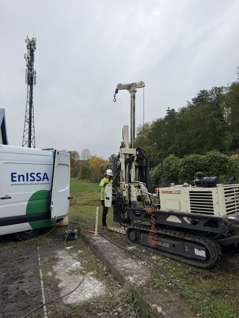
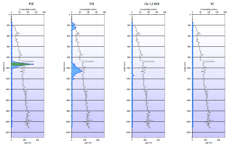
With MIP, we collect measurements almost continuously as the probe advances into the ground. This allows us to identify vertical variations much more precisely.
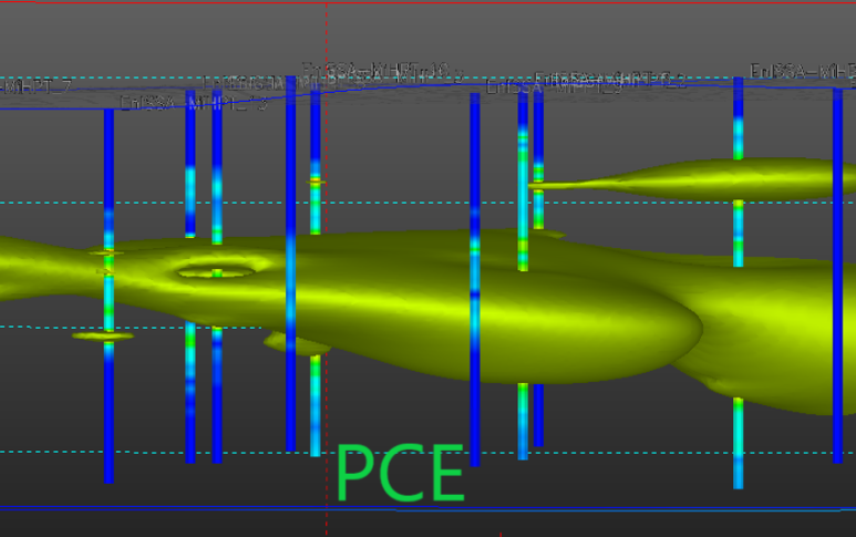
By combining data from multiple probing locations, we can build a three-dimensional picture of where contaminants are located, which layers provide migration pathways and where contaminants are mainly sorbed and continue to be released over time.
This higher resolution does more than simply provide additional information. Crucially, it provides information at the right scale.
For me, high-resolution site investigation is therefore not just about knowing more. It is about measuring at the scale at which contaminants actually behave in the subsurface.
That understanding is essential for identifying the mechanisms driving contaminant migration and selecting a remediation solution that targets the right geological layers and processes.”
You combine MIP with GC-MS. Why is this combination so important?
“Conventional MIP detectors respond to the presence of contamination but cannot distinguish between individual compounds within a mixture.
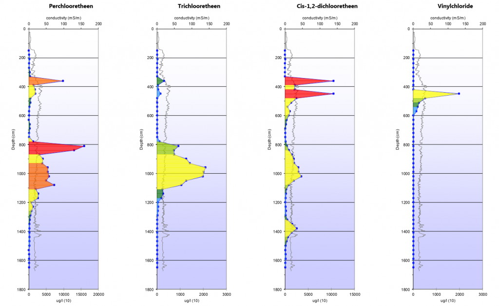
Since 2011, we have combined MIP with GC-MS to create separate profiles for individual compounds such as PCE, TCE and benzene. This gives us a much clearer picture of exactly which contaminants are present and where.
It also helps us interpret the measurements correctly.
Some compounds take longer than others to reach the detectors at the surface. In the meantime, the probe has already advanced deeper into the ground. As a result, contamination can sometimes appear to extend deeper than it actually does.
By identifying individual compounds, we can recognise these delayed signals more accurately.
Furthermore, the relative proportions and spatial distribution of parent compounds and their degradation products provide valuable clues about where natural degradation is taking place and how far it has progressed in different soil layers.
Thanks to the sensitivity of our detection system, we can also trace lower contaminant concentrations further away from the source.
We are increasingly applying this combination of high-resolution data and compound-specific chemical information to projects in France.”
What are the limitations of this approach?
“Our results remain semi-quantitative. Determining exact contaminant concentrations still requires conventional sampling and laboratory analysis.
There are also physical limitations. The probe cannot penetrate every type of ground, particularly hard or coarse-grained layers.
The real added value lies in what we already know before sampling begins.
We help contaminated land specialists identify where additional samples and monitoring wells will genuinely provide the missing information they need.”
What does this mean for clients in France?
“The biggest benefit? Less uncertainty before remediation begins.
A clearer understanding of where contamination is present — and, just as importantly, where it is not — allows us to delineate the source zone more accurately and estimate the volume of soil requiring treatment. This makes remediation cost estimates more reliable.
During implementation, that translates into a more targeted approach.
It reduces the risk of unnecessarily treating large volumes of soil, while also minimising the chance of overlooking contaminated zones and subsequently having to deal with residual contamination or additional remedial measures.
The value of high-resolution site investigation therefore goes beyond simply gathering more information.
It is about reducing uncertainty sufficiently before remediation begins, enabling clients to design more targeted solutions, prepare more realistic budgets and carry out remediation more efficiently.”