PFAS is appearing with increasing frequency in soil investigations. Yet it is persistent, difficult to pin down and, in many situations, highly mobile. Conventional sampling methods often provide only a fragmented picture. And that is a problem… because without a full understanding, you risk remediation that is costly, slow and ultimately ineffective. The solution lies in an approach that truly reads the subsurface: with attention to heterogeneity, permeability, flow paths and storage zones. HRSC (High Resolution Site Characterisation) makes this complex subsurface dynamics visible. (Not yet) by continuously measuring PFAS itself, but by better understanding the subsurface heterogeneity that determines where PFAS is located and where it can migrate to.
A heterogeneous subsurface
The subsurface is rarely homogeneous. Sand, clay, loam and organic-rich layers alternate. And it is precisely this variation that governs the behaviour of PFAS underground. Some PFAS compounds are highly mobile, while others bind more strongly to soil and organic matter. The result is a complex pattern of transport and storage.
What exactly happens?
Permeable layers form the main flow paths, along which the more mobile PFAS compounds can move rapidly.
Less permeable or more organic-rich zones retain PFAS (retention/diffusion).
These less permeable or organic zones can temporarily trap PFAS, after which it is slowly released back into flowing groundwater through diffusion and desorption, a process that can continue for years.
The result: an irregular and unpredictable distribution pattern that cannot be correctly assessed without insight into subsurface heterogeneity.
That is why every PFAS investigation starts in the subsurface. If you do not understand the stratigraphy and flow paths, you miss critical risks and design remediation measures with limited effectiveness.
High-resolution data for PFAS investigations
Unlike VOCs or PAHs (for example with MIP or OIP), PFAS cannot be detected in situ. Even so, HRSC offers major added value. The Hydraulic Profiling Tool (HPT) is a key instrument here.
Hydraulic Profiling Tool
HPT continuously maps soil permeability at high resolution, providing real-time insight into:
The heterogeneity of the subsurface, including:
zones where groundwater (and potentially PFAS) flows most easily;
layers where flow is limited or absent and where PFAS may be retained.
By seeing this subsurface variation more clearly, you can select the right intervals for groundwater analysis. No blind sampling. No unnecessary boreholes, monitoring wells or expensive PFAS analyses that add little value, but targeted sampling where it truly matters.
Smart groundwater sampling
With a GroundWater Profiler (GWP) or temporary monitoring wells (SP16), you can collect groundwater samples quickly and purposefully, without immediately installing a full network of permanent wells.
GWP is ideal in well-permeable sandy layers: one push, multiple intervals.
Temporary monitoring wells provide a larger contact surface, which is useful in less permeable layers. Each sampling event requires an additional sounding.
By combining HPT data with these sampling techniques, you quickly obtain a more complete picture of PFAS transport and potential mass flux. You then verify this in a targeted way with measurements in permanent monitoring wells, which are immediately placed in the right locations for long-term monitoring of PFAS migration and any remediation measures.
Data that speaks: 3D visualisation
HRSC generates large volumes of data. Fortunately, this can be translated into clear and intuitive 3D models:
HPT profiles with pressure and EC;
groundwater results per sampling interval;
volume estimates within defined concentration contours.
This clearly shows how subsurface stratigraphy influences measured groundwater concentrations: which layers retain contamination and which flow paths dominate PFAS migration. It makes remediation choices tangible, for yourself, for fellow experts and for clients.
HRSC provides insight that conventional methods cannot deliver. It makes PFAS visible. Understandable. Manageable. And that gives you what you need most: control.
Want to know more about EnISSA MIP with GC-MS detection?
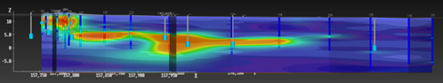
How does PFAS migrate through a complex subsurface? Using high-resolution EC-HPT soundings, our team in Gavere identified permeability contrasts and key stratigraphic transitions in detail. This knowledge underpins targeted sampling, improved monitoring and a realistic assessment of PFAS mobility.
Redeveloping former dry cleaning sites requires certainty about what lies beneath the surface. Using high-resolution site characterisation (HRSC), we map historical chlorinated solvent contamination accurately, even in hard-to-access urban locations. This creates a solid basis for well-informed remediation and viable redevelopment.
On an active production site, we conducted a high-resolution subsurface investigation to precisely identify source zones and contaminant behaviour. By applying HRSC techniques, chemical and geological data were integrated into one coherent model. The results directly supported targeted optimisation of the existing Pump & Treat system.